
Atomionics combines quantum physics and AI to make subsurface mapping faster, cheaper, and dramatically more precise.
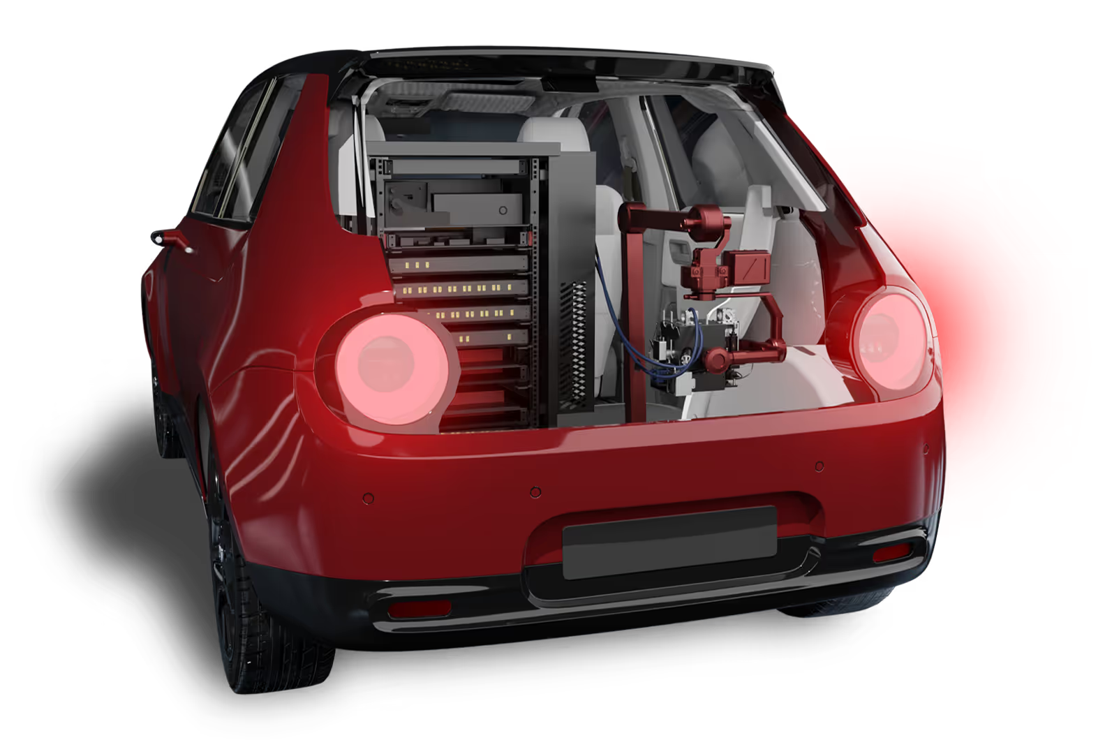
Gravio is the world’s most advanced portable gravimeter built on cold atom interferometry. It acquires high-resolution gravity data from moving platforms, like SUVs and drones, enabling fast, wide-area scans of the Earth’s subsurface. Field-tested across Singapore, Australia, and the US, Gravio unlocks new layers of insight where traditional sensors fail.
Quantum Resolution
100× higher data fidelity than traditional gravity sensors.
Mobile Deployment
Operates on moving SUVs today, drones next.
Extreme Sensitivity
Detects minute subsurface changes using cold atoms.
ORE-O is Atomionics’ AI-powered modeling engine. It transforms raw gravity data into 3D geological maps, emulating the intuition of expert geologists. Unlike probabilistic models, ORE-O delivers deterministic results—showing not just where resources might be but also how much is likely there with confidence.
Smarter Models
AI that mimics geologists to map what’s underground.
3D Clarity
Turns raw data into actionable, drill-ready visuals.
Confident Calls
Predicts what’s there, how deep, and how much—with certainty.
Built by physicists, validated by explorers—Atomionics brings the underground to the surface.
Our quantum sensor GRAVIO gathers ultra-sensitive gravity readings—even in motion—detecting subtle underground variations invisible to legacy tools.
Using AI trained on physics and geology, ORE-O converts raw signals into 3D geological models—mirroring how expert geologists interpret the Earth’s response.
Clients receive high-confidence predictions of resource continuity and volume—before investing in a single drill.
Gravio is powered by cold atom interferometry, a cutting-edge technology that exploits quantum states of atoms to measure variations in the Earth's gravitational field. As atoms experience different gravitational forces, their quantum states undergo changes, which Gravio detects with unparalleled precision. Analyzing these quantum states allows Gravio to provide highly accurate gravity measurements, enabling the identification of gravitational anomalies that may signify concealed resources below the Earth's surface.
Gravimetry has been a vital tool in resource exploration since the 20th century, enabling the detection of subsurface density anomalies through variations in the gravitational potential field. Gravio, with its revolutionary moving-base capability, takes this approach to the next level by facilitating continuous data capture. This empowers geophysicists and exploration teams to swiftly and precisely identify critical minerals, geothermal reservoirs, and other valuable resources, leading to targeted and cost-effective exploration campaigns while minimizing the risk of investing in non-prospective areas.
Gravio's unique high-resolution gravity dataset enables the detection of diverse resources, encompassing critical mineral deposits crucial for the energy transition, hydrocarbon reservoirs, geothermal energy sources, and groundwater reserves, among others.
Gravio's significant contribution to reducing environmental impact stems from its non-invasive and precise sensing capabilities. Unlike certain exploration methods that may involve drilling or ground disturbance, Gravio collects gravity data from the surface without altering the landscape physically. This approach minimizes environmental disruption, decreases carbon emissions related to exploration activities, and facilitates exploration in sensitive or protected areas with minimal impact on the ecosystem. Moreover, Gravio's exceptional high-resolution gravity dataset allows for pinpointing drill targets with greater accuracy, thereby reducing environmental impact from unnecessary drilling and avoiding false positives.
Gravio's versatility extends far beyond resource exploration, as it offers high precision and sensitivity valuable in various scientific and engineering domains. In geodesy, Gravio aids in measuring the Earth's gravitational field, enhancing our understanding of geophysical processes. Additionally, it finds applications in environmental monitoring, enabling the study of groundwater fluctuations, geohazard monitoring, and even contributing to research on climate change's impact on sea level variations. Moreover, Gravio's precise gravity measurements have significance in fundamental physics research, including tests of aspects of Einstein's theory of general relativity.
.gif)


.avif)
.avif)